Politics & Government
New Waterfront Boathouses Could Accommodate Two Universities, Several High Schools
NPS Georgetown non-motorized boathouse zone feasibility study is now open for public comment.

The National Park Service envisions a range of uses and densities in the potential future development of a non-motorized boathouse zone for the Georgetown waterfront that could include room for multiple rowing programs or leave the area relatively undeveloped.
The lowest-density development would include just under 50,000 gross square feet in new buildings on either side of the Key Bridge along the Georgetown waterfront. The most dense would add about 117,000 gross square feet of new space for use by boating enthusiasts, local high schools, universities and others.
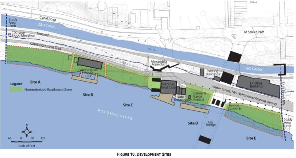
NPS created three development scenarios (high, medium and low density) and looked at five sites along the study area (sites A through E), based on input from community meetings and stakeholder discussions that have occurred over the past year.
Find out what's happening in Georgetownwith free, real-time updates from Patch.
The high density development scenario calls for more than 136 percent more new square footage than the low density scenario.
But NPS noted in its Executive Summary statement, "The feasibility study addresses the ―what and ―where but does not address the ―how questions, which include property ownership, management, construction funding, use and the ultimate users of any particular site."
Find out what's happening in Georgetownwith free, real-time updates from Patch.
This is the first step in what will be a multi-year process. The next step after the NPS receives comments would be to perform an environmental impact study, which would explore alternatives and potential "how" issues.
Site A
This space is the farthest upstream from the Key Bridge and sits just to the west of the Washington Canoe Club.
In both the high- and medium-density plans, NPS proposes a building "that is in scale with the Washington Canoe Club." Both scenarios envision a two-story building with 7,800 square feet on each level. Because of access issues, NPS suggests "the site would best accommodate storage and launch facilities for only canoes, kayaks and single rowing sculls for individual use."
The low-density scenario would include no new building, but would involve trailhead enhancements paired with a pier and beach launch.
Site B (Washington Canoe Club)
All three scenarios call for the reconstruction of the Washington Canoe Club structure.
Site C
This is one of the sites that differs the most among scenarios in terms of new built space.
The high density scenario calls for a more than 36,300 square-foot, three-story structure. There would be 9,900 square feet of space on the ground floor split into two buildings with a shared apron and then the second and third levels would each boast 13,200 square feet.
According to NPS, "This configuration would permit existing sewer access structures to be integrated into the design of the apron to maintain access. Upper levels of the structure could bridge the shared apron to permit the maximum allowable floor area for other program elements."
Both the medium- and low-density scenarios would use this space for a car-top launch, but there would be no additional buildings or construction.
Sites D and E
"Large boathouses could be developed on Sites D and E and could accommodate two university programs and most high school programs and provide sufficient space for other activities such as rowing tanks, erg rooms, meeting and locker rooms, and caretaker quarters on upper levels," the NPS suggests in both the the high- and medium-density scenarios.
On Site D just to the west of the Key Bridge there would be three full and a fourth partial story, bringing the structure to the same height as the Whitehurst Freeway. It would have 7,800 square feet on each of three stories and then a partial fourth floor. It also assumes the acquisition and development of private lots currently located on the site.
The low-density plan calls for a one-story, 5,000-square-foot building on Site D.
"Existing operations, property ownership, and tree cover would be retained on Site D, and additional storage for paddlecraft would be integrated into the existing site in place of parking, which would need to be replaced off-site," suggests NPS in the low-density plan.
Site E just to the east of the Key Bridge would be the largest structure by far and appears in all three scenarios.
The study suggests a three-story structure with 13,800 square feet on each level. There would be parallel storage and loading with an apron at the west end of the building and a "public launch plaza with rental storage racks at east end of site adjacent to Georgetown Waterfront Park."
The study can be found online http://parkplanning.nps.gov/nmbz and NPS will accept comments for the next 30 days.
NPS will host a public open house Wednesday, May 22, from 6 to 8 p.m. in the large meeting room at the West End Library, 1101 24th St. NW.
Which of the scenarios do you prefer? Tell us in the comments.
Get more local news delivered straight to your inbox. Sign up for free Patch newsletters and alerts.
